Maps for good
Leah Rumon
Geography & GIS Professional (AKA, map-nerd)
See what I can do with Spatial Data
Work
I am an awarded, emerging GIS professional passionate about making maps for good, primarily in local government. Maps are a universal language, and I enjoy creating user-focused solutions to address important issues and streamline daily workflows. I have experience in various areas of GIS, from environmental sustainability to public works. My background includes a BA in Geography and GIS from the University of St. Thomas and my ongoing pursuit of a master’s degree in Geographic Information Science (MGIS) at the University of Minnesota. I am excited to further develop my geospatial skills to help create solutions for a more sustainable and efficient future!
Geographic Highlights
Project Types

diSOLVE

I developed a prototype GIS and Python model that evaluates winter road icing risk by combining terrain, road geometry, solar exposure, and weather behavior. The workflow produces localized risk scores to support more targeted and environmentally conscious winter maintenance decisions.
Associated Skills
GIS Analysis | Python (ArcPy) | Raster & Vector Modeling | Solar Radiation Analysis | Terrain Analysis | Workflow Automation | Decision-Support Modeling | Data Visualization
GIS Contractor

I completed GIS spatial analysis support for data-intensive address and location-matching workflows, focusing on large, multi-jurisdictional datasets. The work emphasized data normalization, scalable processing, and reproducible geospatial outputs to support downstream analysis and decision-making.
Associated Skills
GIS Data Engineering | Python | Address Standardization | Large-Scale Data Processing | Spatial Matching | Workflow Optimization | Data Quality Assurance | CSV & GeoJSON Pipelines
To Tree or Not to Tree
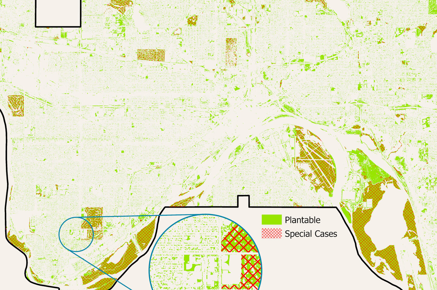
I developed an independent GIS analysis to test where trees could realistically be planted across St. Paul, Minnesota. The tool I built combines raster and vector datasets to classify land as plantable, non-plantable, tree-covered, or water, then layers in municipal code restrictions, cultural land-use norms, and ownership boundaries. The result is a grounded model that reveals the true feasibility of urban planting and supports more informed forestry planning.
Associated Skills
GIS Analysis | Raster & Vector Spatial Modeling | Data Integration | Municipal Policy Translation | Urban Forestry Planning | Data Visualization Independent Research | Self-Directed Workflow Design
Photo Organization Utility

I built IndexMapr, a Python-based tool that organizes field photos into a logical folder system so they can be quickly accessed and understood. The notebook reads spreadsheets or ArcGIS tables, detects valid image URLs, and downloads them into folders sorted by street and house, even grouping streets by initial or number range. This project makes field documentation faster, clearer, and easier to maintain for future use.
Associated Skills
Python | Pandas | ArcPy | Data Cleaning | Regex | File Automation | Geospatial Workflows
Twin Cities & Urban Heat Islands
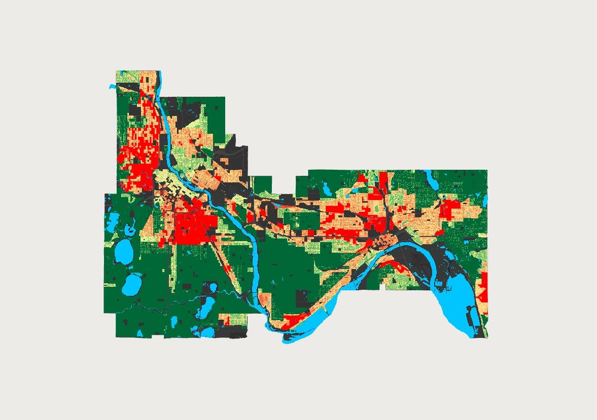
This project, completed as independent research, analyzed multiple data sets to find areas of the Twin Cities Metro most vulnerable to urban heat islands and suggested ways to mitigate the effects on residents. Additionally, this project was presented at the 2022 Minnesota GIS/LIS Consortium Conference & won first place in the undergraduate student presentation competition.
Associated Skills
Academic Writing | Presentation | Research | Independent Study | Self-Direction | Data Analysis | ArcGIS Pro | StoryMaps | Data Visualization
Minnesota GeoPEPS
As a volunteer on multiple committees for the Minnesota GIS/LIS Consortium, I felt a need to create a resource for emerging professionals and students. As a representative from the higher education committee (and a recent graduate), I collaborated with a colleague from the professional development committee to design an easy-to-use portal with information that emerging pros and students need to get involved in the GIS world.
Associated Skills
Collaboration | Adaptability | Project Management | Cross Organization Work | Hub Sites | Dashboards | Volunteer Work
Guide to Survey123 Geopoints
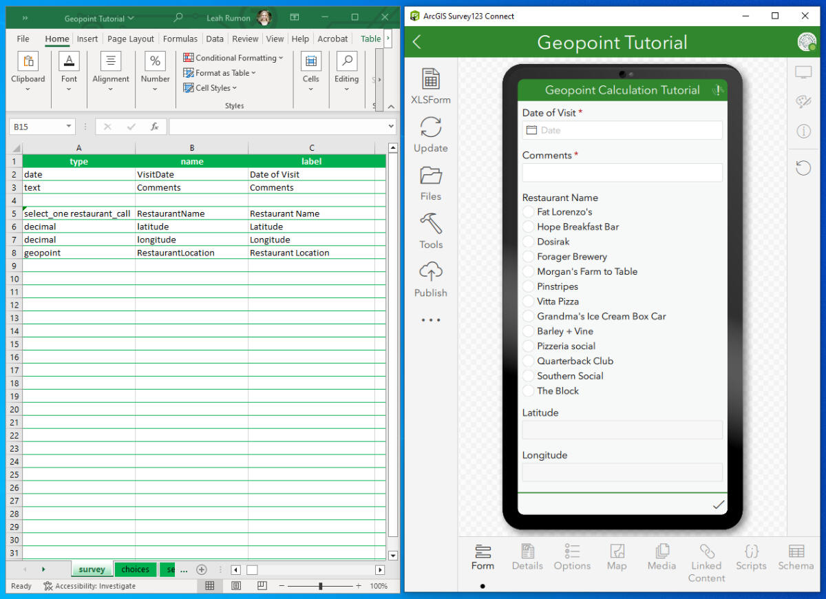
I am an advocate for sharing resources and documenting work so that it can be easily shared, replicated, or fixed in the future (thanks, error 999999). Especially when I am trying something new. This guide, made with StoryMaps, walks the user through the process of automatically calculating geo-points using Survey123 Connect. This feature can be extremely useful when there can be no disparity within points.
Associated Skills
Problem Solving | Training | Adjacent Skills | Documentation | Survey123 | ArcGIS Online | Tech-Based Communication
Elections & Polling Site
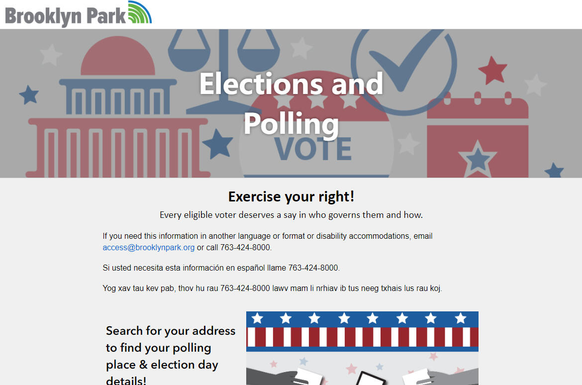
During my internship for the City of Brooklyn Park, two of my tasks were to learn Experience Builder and create a resource for residents to easily search for their polling information. This project represents the intersection of many skills utilized with ArcGIS Online and making resources available to the public.
Associated Skills
Accessibility | Web Apps | Web Map | Experience Builder | UI/UX Design | Arcade
These are just a few highlights & skills associated with the work I have done. For more work examples, view my ArcGIS Online.
My professional experiences have taken place at The University of St. Thomas, the City of Brooklyn Park, ERM, the City of Apple Valley, and The Center for Urban and Regional Affairs (CURA)
! The data products and maps in this portfolio were created for educational, personal, volunteer, or professional purposes, including work from previous jobs and internships as allowed. Some content has been redacted as required. These materials are not intended for navigational use, and their accuracy, completeness, and timeliness cannot be guaranteed. The creators and affiliated institutions assume no legal liability or responsibility for the use of this information.
Get to know me
Your Friendly Neighborhood Map Maker
Believe it or not, I do a bit more than just make maps (although I digress, sometimes I do make them for fun).
I am an avid Tolkien fan and wish I could spend all of my time adventuring. Although the hobbit lifestyle is a bit out of reach, I do my best to make up for it by spending time outside with my dog & horse. My go-to hobbies are baking, language learning, reading, traveling, and sharpening my Mario Kart skills.
My next map-related goals are:
Add more places to my food map (see below!)
Map some trails with my pets
Improve my cartography skills
Make digital fantasy maps
Honors & Notable Events
The University of St. Thomas Interdepartmental Award - Geography & GIS Student of the Year (2021/22)
Presenter at the 2022 Minnesota GIS/LIS Consortium Conference - first-place undergraduate presentation award
Undergraduate Research Opportunities Program (UROP) grant recipient
Dean's Honor List - The University of St. Thomas (Fall 2021, Spring 2022)
Minnesota GIS/LIS Consortium Conference Panelist for Professional Development in GIS (2023)
MN GIS/LIS Emerging Professional Award Recipient (2024)
Minnesota GIS/LIS Member October Spotlight - Associated with Emerging Professional Award (2024)
Keep in touch
Contact Me!
🌎
Interested in chatting more?
Connect with me on LinkedIn, view more of my work on ArcGIS Online, or fill out the form to send me an email.Happy Mapping :-)
Map Gallery
click to enlarge

UMN Cartography: Populations Served by Transit Options

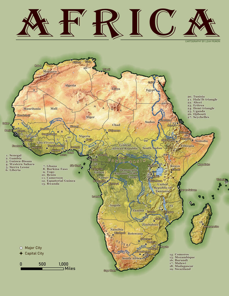
UMN Cartography: Countries, Cities and Landscapes of Africa

UMN Cartography: The Pacific Northwest

Crime Map Layout (ArcGIS Pro) - Originally made for the City of Apple Valley

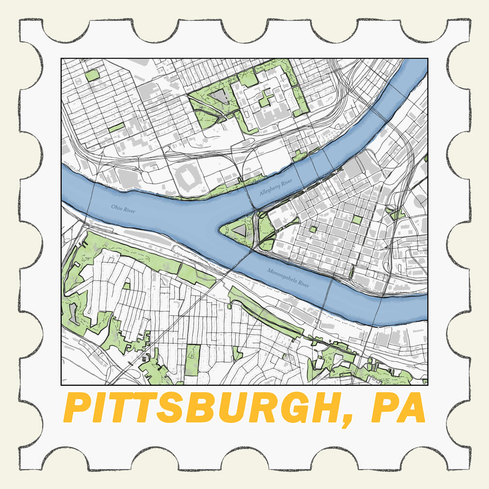
Personal Project: Stamp Maps

City of Apple Valley - General Display

CURA: HUP Project Infographic

Top Crops

Park Map - City of Apple Valley


